
Thank you for supporting this site ❤️
Make a donation
Make a donation
Begonte topographic map
Click on the map to display elevation.
Thank you for supporting this site ❤️
Make a donation
Make a donation
About this map
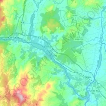
Name: Begonte topographic map, elevation, terrain.
Location: Begonte, Terra Chá, Lugo, Galicia, Spain (43.09300 -7.78624 43.21444 -7.59529)
Average elevation: 454 m
Minimum elevation: 377 m
Maximum elevation: 733 m
Thank you for supporting this site ❤️
Make a donation
Make a donation
Other topographic maps
Click on a map to view its topography, its elevation and its terrain.
Thank you for supporting this site ❤️
Make a donation
Make a donation