
Thank you for supporting this site ❤️
Make a donation
Make a donation
Kargıcak topographic map
Click on the map to display elevation.
Thank you for supporting this site ❤️
Make a donation
Make a donation
About this map
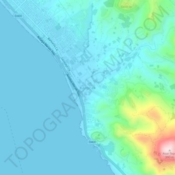
Name: Kargıcak topographic map, elevation, terrain.
Location: Kargıcak, Alanya, Antalya, Mediterranean Region, 07435, Turkey (36.44101 32.10534 36.48101 32.14534)
Average elevation: 54 m
Minimum elevation: -1 m
Maximum elevation: 394 m
Thank you for supporting this site ❤️
Make a donation
Make a donation
Other topographic maps
Click on a map to view its topography, its elevation and its terrain.