
Thank you for supporting this site ❤️
Make a donation
Make a donation
Heuvelland topographic map
Click on the map to display elevation.
Thank you for supporting this site ❤️
Make a donation
Make a donation
About this map
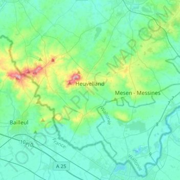
Name: Heuvelland topographic map, elevation, terrain.
Location: Heuvelland, Ieper, West Flanders, Belgium (50.70828 2.71302 50.82732 2.96047)
Average elevation: 35 m
Minimum elevation: 9 m
Maximum elevation: 152 m
Thank you for supporting this site ❤️
Make a donation
Make a donation
Other topographic maps
Click on a map to view its topography, its elevation and its terrain.
Polderhoek
Belgium > West Flanders > Ieper > Zonnebeke > Geluveld > Poezelhoek
Average elevation: 45 m
Thank you for supporting this site ❤️
Make a donation
Make a donation