
Thank you for supporting this site ❤️
Make a donation
Make a donation
Campo Maior topographic map
Click on the map to display elevation.
Thank you for supporting this site ❤️
Make a donation
Make a donation
About this map
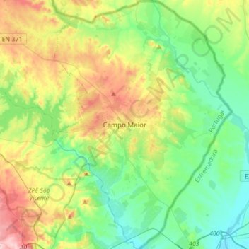
Name: Campo Maior topographic map, elevation, terrain.
Location: Campo Maior, Portalegre, Portugal (38.90585 -7.14936 39.11839 -6.95113)
Average elevation: 240 m
Minimum elevation: 166 m
Maximum elevation: 397 m
Thank you for supporting this site ❤️
Make a donation
Make a donation
Other topographic maps
Click on a map to view its topography, its elevation and its terrain.
Relva da Asseiceira
Portugal > Portalegre > Marvão > Santo António das Areias
Average elevation: 482 m
Thank you for supporting this site ❤️
Make a donation
Make a donation
Thank you for supporting this site ❤️
Make a donation
Make a donation