
San Gil topographic map
Interactive map
Click on the map to display elevation.
About this map
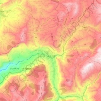
Name: San Gil topographic map, elevation, terrain.
Location: San Gil, Guanentá, Santander, RAP Gran Santander, Colombia (6.47968 -73.21125 6.65028 -73.02861)
Average elevation: 1,505 m
Minimum elevation: 734 m
Maximum elevation: 2,023 m
Other topographic maps
Click on a map to view its topography, its elevation and its terrain.
Mirador del Cañon del Chicamocha
Colombia > Santander > Jordán > Villanueva
Average elevation: 1,139 m
Floridablanca
Colombia > Santander > Floridablanca > Floridablanca
Floridablanca is situated at an altitude of about 925 metres (3,035 ft) in the Eastern Ranges of the Colombian Andes, though locally the topography varies greatly. To the east of the city the higher mountains of the Andes rise above the city, thrusted upwards by the north–south-trending Bucaramanga-Santa…
Average elevation: 1,091 m