
Make a donation
Ovifat topographic map
Click on the map to display elevation.
Make a donation
About this map
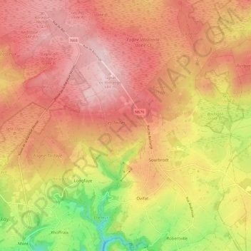
Name: Ovifat topographic map, elevation, terrain.
Location: Ovifat, Robertville, Waimes, Verviers, Liège, Wallonia, Belgium (50.45145 6.06312 50.52245 6.12216)
Average elevation: 591 m
Minimum elevation: 414 m
Maximum elevation: 701 m
Make a donation
Other topographic maps
Click on a map to view its topography, its elevation and its terrain.
Ardennes
Belgium > Liège > Verviers > Robertville
The region the Ardennes are part of has been uplifted further in the last few hundred thousand years by a mantle plume, as measured from the present elevation of old river terraces, with the largest amount of uplift concentrated in the east, where the Ardennes connect with the Eifel, where the same mantle…
Average elevation: 659 m
Ardennes
Belgium > Liège > Verviers > Robertville
The region was uplifted by a mantle plume during the last few hundred thousand years, as measured from the present elevation of old river terraces.
Average elevation: 659 m
Signal de Botrange
Belgium > Liège > Verviers > Robertville
In 1923, the 6-metre (20-foot) Baltia tower was built on the summit to allow visitors to reach an altitude of 700 m (2,300 ft). A stone tower built in 1933/34 by François Fagnoul from Ovifat on the Botrange crowned a steel weather vane with the relieved name SICCO CAMPO until World War II. Meanwhile, the…
Average elevation: 658 m