
Make a donation
Marshall County topographic map
Click on the map to display elevation.
Make a donation
About this map
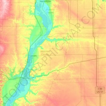
Name: Marshall County topographic map, elevation, terrain.
Location: Marshall County, Illinois, United States (40.92147 -89.63919 41.14870 -89.04675)
Average elevation: 201 m
Minimum elevation: 131 m
Maximum elevation: 292 m
Make a donation
Other topographic maps
Click on a map to view its topography, its elevation and its terrain.
Make a donation
Make a donation
Make a donation
Make a donation
Make a donation
Make a donation
Make a donation
Make a donation
Make a donation
Make a donation
Make a donation
Make a donation
Make a donation
Elmhurst
United States > Illinois > DuPage County
Due to local topography, the town has had a tendency to flood in the past after large rainfalls; the city is currently undertaking a large effort to mitigate future flooding.
Average elevation: 207 m
Make a donation
Make a donation
Make a donation
Make a donation
Make a donation
Make a donation
Make a donation
Make a donation
Elmhurst
United States > Illinois > DuPage County
Due to local topography, the town has had a tendency to flood in the past after large rainfalls; the city is currently undertaking a large effort to mitigate future flooding.
Average elevation: 207 m
Make a donation
Make a donation
Make a donation
Make a donation