
K2 topographic map
Click on the map to display elevation.
K2
Also occasionally known as Mount Godwin-Austen, other nicknames for K2 are The King of Mountains and The Mountaineers' Mountain, as well as The Mountain of Mountains after prominent Italian climber Reinhold Messner titled his book about K2 the same. Although the summit of Everest is at a higher altitude, K2 is a more difficult and dangerous climb. This is due in part to its more northern location, where inclement weather is more common. The summit was reached for the first time by the Italian climbers Lino Lacedelli and Achille Compagnoni on a 1954 Italian expedition led by Ardito Desio.
About this map
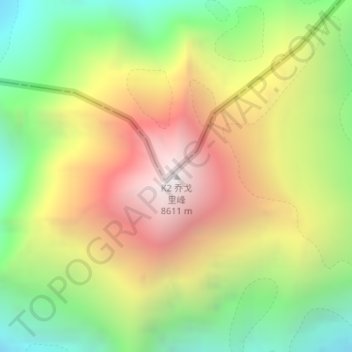
Name: K2 topographic map, elevation, terrain.
Average elevation: 7,474 m
Minimum elevation: 6,440 m
Maximum elevation: 8,611 m
Other topographic maps
Click on a map to view its topography, its elevation and its terrain.
Biafo Glacier
Pakistan > Gilgit-Baltistan > Shigar District
Biafo Glacier converging at Hispar La with 49 kilometres (30 mi) long Hispar Glacier situated at an elevation of 5,128 metres (16,824 ft), forms the glacial system considered as the world's longest non-polar glacial system which spans an overall distance of around 120 kilometres (75 mi). This frozen pathway…
Average elevation: 4,618 m