
Make a donation
Spézet topographic map
Click on the map to display elevation.
Make a donation
Spézet
Spézet is a rural municipality in east central Finistère, historically belonging to Cornouaille. It is bounded on the west and north by the river the Aulne and Hyères describing large meanders (Nantes-Brest Canal-channel) while at the southeast end of its territory lies Roc'h Toullaëron, which from its height of 318 m is the culmination of the Black Mountains. The village occupies a small hill whose altitude is around 100 meters northwest of the town. Spézet is border by Saint-Hernin to the east, by Gourin to the southeast, by Roudouallec to the south, by Saint-Goazec to the southwest, by Châteauneuf-du-Faou to the west and by Plonévez-du-Faou, Landeleau and Cleden-Poher to the north.
Make a donation
About this map
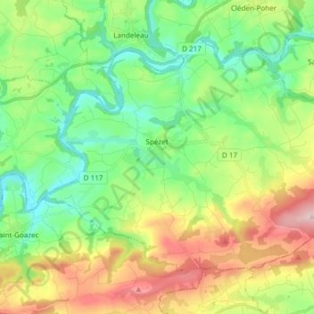
Name: Spézet topographic map, elevation, terrain.
Average elevation: 136 m
Minimum elevation: 40 m
Maximum elevation: 310 m
Make a donation
Other topographic maps
Click on a map to view its topography, its elevation and its terrain.
Make a donation
Résidence du Bois Pleuven
France > Brittany > Finistère > Résidence du Bois Pleuven
Average elevation: 97 m
Make a donation
Make a donation
Make a donation
Make a donation
Make a donation
Make a donation
Make a donation
Make a donation
Make a donation
Moulin du Bois
France > Brittany > Finistère > Hôpital-Camfrout > L'Hôpital-Camfrout
Average elevation: 48 m
Make a donation
Make a donation
Make a donation
Make a donation
Make a donation