
Thank you for supporting this site ❤️
Make a donation
Make a donation
Cabeças topographic map
Click on the map to display elevation.
Thank you for supporting this site ❤️
Make a donation
Make a donation
About this map
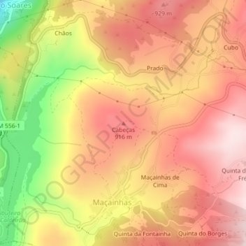
Name: Cabeças topographic map, elevation, terrain.
Location: Cabeças, Guarda, 6300-126, Portugal (40.53278 -7.31234 40.53288 -7.31224)
Average elevation: 833 m
Minimum elevation: 588 m
Maximum elevation: 977 m
Thank you for supporting this site ❤️
Make a donation
Make a donation
Other topographic maps
Click on a map to view its topography, its elevation and its terrain.