
Thank you for supporting this site ❤️
Make a donation
Make a donation
Olot topographic map
Click on the map to display elevation.
Thank you for supporting this site ❤️
Make a donation
Make a donation
About this map
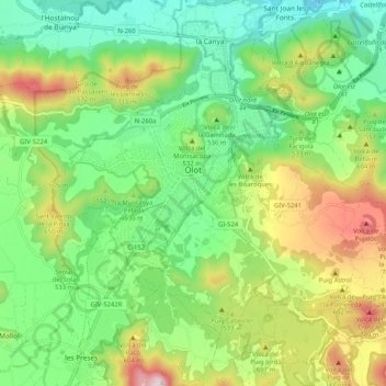
Name: Olot topographic map, elevation, terrain.
Location: Olot, Garrotxa, Girona, Catalonia, Spain (42.14974 2.44638 42.20532 2.54909)
Average elevation: 499 m
Minimum elevation: 293 m
Maximum elevation: 881 m
Thank you for supporting this site ❤️
Make a donation
Make a donation
Other topographic maps
Click on a map to view its topography, its elevation and its terrain.