
Make a donation
Margarita Island topographic map
Click on the map to display elevation.
Make a donation
Margarita Island
The Macanao peninsula to the west has a central mountain range in the east–west direction. The highest altitude is 760 metres (2,493 ft) at Pico de Macanao. Several smaller ranges derive from this axis following a north–south orientation with deep valleys between them. The most notable of these valleys is San Francisco in the north-central part of the peninsula. The Paraguachoa peninsula to the East is formed by a mountain range in the north–south direction from Porlamar to Cabo Negro. The highest peaks are San Juan or Cerro Grande at 920 metres (3,018 ft) and El Copey 890 metres (2,920 ft). The peninsulas are connected by the La Restinga isthmus, on which the La Restinga lagoon is located. There are also two breast-shaped hills known as Tetas de Maria Guevara on the isthmus.
Make a donation
About this map
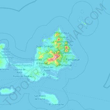
Name: Margarita Island topographic map, elevation, terrain.
Average elevation: 12 m
Minimum elevation: -2 m
Maximum elevation: 890 m
Make a donation