
Make a donation
Čačak topographic map
Click on the map to display elevation.
Make a donation
About this map
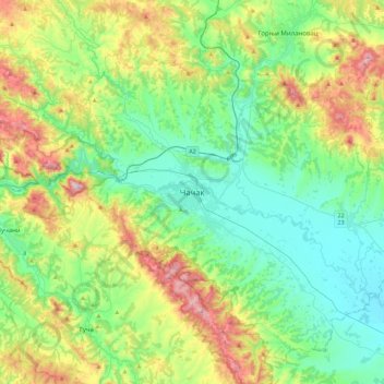
Name: Čačak topographic map, elevation, terrain.
Average elevation: 418 m
Minimum elevation: 200 m
Maximum elevation: 960 m
Make a donation
Other topographic maps
Click on a map to view its topography, its elevation and its terrain.
Ozrem
Serbia > Central Serbia > Moravica Administrative District > Gornji Milanovac Municipality
Average elevation: 459 m
Donja Vrbava
Serbia > Central Serbia > Moravica Administrative District > Gornji Milanovac Municipality
Average elevation: 534 m
Zagradje
Serbia > Central Serbia > Moravica Administrative District > Gornji Milanovac Municipality
Average elevation: 409 m
Gornji Milanovac
Serbia > Central Serbia > Moravica Administrative District > Gornji Milanovac Municipality
Gornji Milanovac and the villages of Varnice, Zagradje, Dragolj and Trudelj are dominated by the Ostrvica Massif. The elevation of Ostrvica is 758 metres (2,487 ft). Ostrvica is actually the remains of a destroyed volcanic cone. In May 2009, Ostrvica was declared a natural monument. In the middle of the last…
Average elevation: 377 m
Make a donation
Ivanjica
Serbia > Central Serbia > Moravica Administrative District > Ivanjica Municipality
Ivanjica lies in the southwest of Serbia, at the bank of the Moravica river. It is surrounded by the mountain ranges of Golija, Javor, Mučanj, Čemerno and Radočelo and is in a valley. Ivanjica's highest elevation is 1833 m, at the Jankov Kamen peak. The mountains in this area belong to the Dinaric range.…
Average elevation: 599 m
Pranjani
Serbia > Central Serbia > Moravica Administrative District > Gornji Milanovac Municipality
Average elevation: 484 m
Donji Dubac
Serbia > Central Serbia > Moravica Administrative District > Lucani Municipality
Average elevation: 680 m
Donji Dubac
Serbia > Central Serbia > Moravica Administrative District > Lucani Municipality
Average elevation: 680 m
Make a donation
Ivanjica
Serbia > Central Serbia > Moravica Administrative District > Ivanjica Municipality
Ivanjica lies in the southwest of Serbia, at the bank of the Moravica river. It is surrounded by the mountain ranges of Golija, Javor, Mučanj, Čemerno and Radočelo and is in a valley. Ivanjica's highest elevation is 1833 m, at the Jankov Kamen peak. The mountains in this area belong to the Dinaric range.…
Average elevation: 599 m
Guca
Serbia > Central Serbia > Moravica Administrative District > Lucani Municipality
Average elevation: 404 m
Pranjani
Serbia > Central Serbia > Moravica Administrative District > Gornji Milanovac Municipality
Average elevation: 484 m
Make a donation
Gornji Milanovac Municipality
Serbia > Central Serbia > Moravica Administrative District
Average elevation: 425 m
Ivanjica Municipality
Serbia > Central Serbia > Moravica Administrative District
Average elevation: 1,039 m
Make a donation
Trudelj
Serbia > Central Serbia > Moravica Administrative District > Gornji Milanovac Municipality
Average elevation: 394 m
PIO Ovčar-Kablar Gorge
Serbia > Central Serbia > Moravica Administrative District > Lucani Municipality
The spa of Ovčar Banja is located in the gorge, at an altitude of 278 meters. It has a hot, sulfuric water (37,5 Celsius), which is helpful for the treatment of rheumatism, nerve and skin diseases.
Average elevation: 477 m