
Make a donation
Putumayo topographic map
Click on the map to display elevation.
Make a donation
About this map
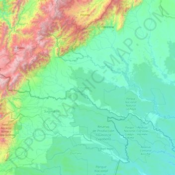
Name: Putumayo topographic map, elevation, terrain.
Location: Putumayo, RAP Amazonía, Colombia (-0.55315 -77.18680 1.46782 -73.84132)
Average elevation: 677 m
Minimum elevation: 152 m
Maximum elevation: 4,390 m
Make a donation
Other topographic maps
Click on a map to view its topography, its elevation and its terrain.
Make a donation
Centro Experimental Gaviotas
Gaviotas has leveraged many forms of solar energy. They developed solar heating panels to provide hot water, which were installed in Gaviotas homes and housing developments in Medellín. The original design was not suited for Bogotá, however, since at 2,600 meters of altitude (9,000 ft) the city has a cooler…
Average elevation: 176 m
Make a donation
Make a donation
Floridablanca
Colombia > Santander > Floridablanca > Floridablanca
Floridablanca is situated at an altitude of about 925 metres (3,035 ft) in the Eastern Ranges of the Colombian Andes, though locally the topography varies greatly. To the east of the city the higher mountains of the Andes rise above the city, thrusted upwards by the north–south-trending Bucaramanga-Santa…
Average elevation: 1,091 m
Make a donation