
Thank you for supporting this site ❤️
Make a donation
Make a donation
Piétrain topographic map
Click on the map to display elevation.
Thank you for supporting this site ❤️
Make a donation
Make a donation
About this map
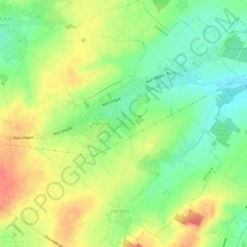
Name: Piétrain topographic map, elevation, terrain.
Location: Piétrain, Jodoigne, Nivelles, Brabant wallon, Wallonie, Belgique (50.70826 4.89996 50.74268 4.94887)
Average elevation: 90 m
Minimum elevation: 64 m
Maximum elevation: 118 m
Thank you for supporting this site ❤️
Make a donation
Make a donation
Other topographic maps
Click on a map to view its topography, its elevation and its terrain.