
Nouâtre topographic map
Interactive map
Click on the map to display elevation.
About this map
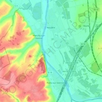
Name: Nouâtre topographic map, elevation, terrain.
Average elevation: 64 m
Minimum elevation: 31 m
Maximum elevation: 121 m
Other topographic maps
Click on a map to view its topography, its elevation and its terrain.
Descartes
France > Centre-Val de Loire > Indre-et-Loire
Descartes, Loches, Indre-et-Loire, Centre-Val de Loire, Metropolitan France, 37160, France
Average elevation: 90 m
L'Île-Bouchard
France > Centre-Val de Loire > Indre-et-Loire
L'Île-Bouchard, Chinon, Indre-et-Loire, Centre-Val de Loire, Metropolitan France, 37220, France
Average elevation: 41 m