
Thank you for supporting this site ❤️
Make a donation
Make a donation
Fosnavåg topographic map
Click on the map to display elevation.
Thank you for supporting this site ❤️
Make a donation
Make a donation
About this map
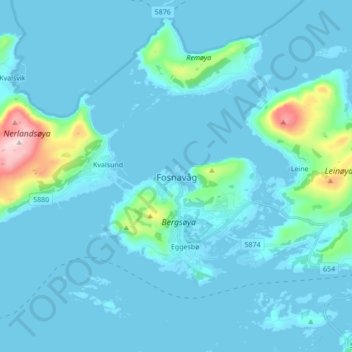
Name: Fosnavåg topographic map, elevation, terrain.
Location: Fosnavåg, Herøy, Мёре-ог-Ромсдал, 6090, Норвегия (62.30211 5.59424 62.38211 5.67424)
Average elevation: 36 m
Minimum elevation: -6 m
Maximum elevation: 422 m
Thank you for supporting this site ❤️
Make a donation
Make a donation
Other topographic maps
Click on a map to view its topography, its elevation and its terrain.