Geolocate

Almașu Mic topographic map

Click on the map to display elevation.

About this map

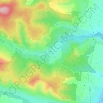
Name: Almașu Mic topographic map, elevation, terrain.

Location: Almașu Mic, Peștișu Mic, Hunedoara, 337336, Romania (45.79830 22.87312 45.83830 22.91312)

Average elevation: 298 m

Minimum elevation: 214 m

Maximum elevation: 439 m

Other topographic maps

Click on a map to view its topography, its elevation and its terrain.

Orăștie

Romania > Hunedoara

Average elevation: 249 m

Retezat National Park

Romania > Hunedoara

Average elevation: 1,443 m

Lupeni

Romania > Hunedoara

Average elevation: 1,082 m

Bănița

Romania > Hunedoara

Average elevation: 924 m

Călan

Romania > Hunedoara

The town is located in the central part of the county, in the historical Țara Hațegului region. It lies in the Strei River valley, at 230 m (750 ft) altitude.

Average elevation: 312 m

Bătrâna

Romania > Hunedoara

Bătrâna is located in the western part of Hunedoara County, about 53 km (33 mi) southwest of the county seat, Deva, on the border with Timiș County. It is situated in a mountainous landscape north of the Poiana Ruscă Mountains, at an altitude of 960 m (3,150 ft). The river Ciorman flows through the…

Average elevation: 695 m

Orăștioara de Sus

Romania > Hunedoara

Average elevation: 699 m

Sarmizegetusa

Romania > Hunedoara

Average elevation: 887 m

Blăjeni

Romania > Hunedoara

Average elevation: 727 m

Vața de Jos

Romania > Hunedoara

Average elevation: 446 m

Aninoasa

Romania > Hunedoara

Average elevation: 773 m

Deva

Romania > Hunedoara

Average elevation: 289 m

Ghelari

Romania > Hunedoara

Average elevation: 583 m

Bucura Lake

Romania > Hunedoara > Râu de Mori

Lake Bucura is a glacier cirque lake, situated in the Retezat Mountains, in Romania. It is located south of the main ridge, at the base of Peleaga Peak, and at an altitude of about 2,040 m.

Average elevation: 2,137 m

Pui

Romania > Hunedoara

Average elevation: 856 m

Hunedoara

Romania > Hunedoara

Average elevation: 331 m

Geoagiu

Romania > Hunedoara

Average elevation: 451 m

Hărău

Romania > Hunedoara

Average elevation: 264 m

Boholt

Romania > Hunedoara

Average elevation: 318 m

Sălașu de Sus

Romania > Hunedoara

Average elevation: 1,019 m

Orăștioara de Sus

Romania > Hunedoara

Average elevation: 699 m

Hațeg

Romania > Hunedoara

Average elevation: 365 m

Vulcan

Romania > Hunedoara

Average elevation: 919 m

Petroșani

Romania > Hunedoara

Average elevation: 1,137 m

Brad

Romania > Hunedoara

Average elevation: 415 m

Baru

Romania > Hunedoara > Baru

Average elevation: 533 m

Deva

Romania > Hunedoara

Average elevation: 289 m

Călan

Romania > Hunedoara

The town is located in the central part of the county, in the historical Țara Hațegului region. It lies in the Strei River valley, at 230 m (750 ft) altitude.

Average elevation: 312 m

Hărțăgani

Romania > Hunedoara > Hărțăgani

Average elevation: 394 m

Căzănești

Romania > Hunedoara

Average elevation: 419 m

Simeria

Romania > Hunedoara > Simeria

Average elevation: 259 m

Petroșani

Romania > Hunedoara > Petroșani

Average elevation: 721 m

Fundatura Ponorului

Romania > Hunedoara

Average elevation: 975 m

Vața de Jos

Romania > Hunedoara > Vața de Jos

Average elevation: 255 m

Petrila

Romania > Hunedoara

Average elevation: 1,097 m

Petroșani

Romania > Hunedoara

Average elevation: 1,137 m

Râu de Mori

Romania > Hunedoara

Average elevation: 1,228 m