
Make a donation
Chilpancingo de los Bravo topographic map
Click on the map to display elevation.
Make a donation
About this map
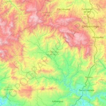
Name: Chilpancingo de los Bravo topographic map, elevation, terrain.
Location: Chilpancingo de los Bravo, Guerrero, Mexico (17.17359 -100.06095 17.61009 -99.38703)
Average elevation: 1,308 m
Minimum elevation: 63 m
Maximum elevation: 3,287 m
Make a donation
Other topographic maps
Click on a map to view its topography, its elevation and its terrain.
Acapulco
Mexico > Guerrero > Acapulco de Juárez
The city, located on the Pacific coast of Mexico in the state of Guerrero, is classified as one of the state's seven regions, dividing the rest of the Guerrero coast into the Costa Grande and the Costa Chica. Forty percent of the municipality is mountainous terrain; another forty percent is semi-flat; and the…
Average elevation: 99 m
Colonia del Obispo (Loma del Obispo)
Mexico > Guerrero > Malinaltepec > Malinaltepec
Average elevation: 1,870 m
Make a donation
Coahuayutla de Guerrero
Mexico > Guerrero > Coahuayutla de José María Izazaga
Average elevation: 340 m
Make a donation
Zihuatanejo
Mexico > Guerrero > Zihuatanejo de Azueta
The town of Zihuatanejo is the seat of the municipality of Zihuatanejo de Azueta and as such is the governmental authority for approximately 416 communities, with a total population of 104,609 as of 2005, and an area of 1,921.5 km2 (741.9 sq mi). There are small indigenous communities in the municipality which…
Average elevation: 103 m
Acapulco
Mexico > Guerrero > Acapulco de Juárez
The city, located on the Pacific coast of Mexico in the state of Guerrero, is classified as one of the state's seven regions, dividing the rest of the Guerrero coast into the Costa Grande and the Costa Chica. Forty percent of the municipality is mountainous terrain; another forty percent is semi-flat; and the…
Average elevation: 99 m
Make a donation
Centro Internacional Acapulco
Mexico > Guerrero > Acapulco de Juárez > Acapulco
Average elevation: 68 m
Make a donation
Make a donation
Acapulco
Mexico > Guerrero > Acapulco de Juárez
The city, located on the Pacific coast of Mexico in the state of Guerrero, is classified as one of the state's seven regions, dividing the rest of the Guerrero coast into the Costa Grande and the Costa Chica. Forty percent of the municipality is mountainous terrain; another forty percent is semi-flat; and the…
Average elevation: 99 m
Las Juntas de Chacámero
Mexico > Guerrero > Pungarabato > Las Juntas de Chacámero
Average elevation: 256 m
Make a donation