
Make a donation
Payogasta topographic map
Click on the map to display elevation.
Make a donation
About this map
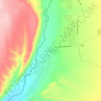
Name: Payogasta topographic map, elevation, terrain.
Average elevation: 2,489 m
Minimum elevation: 2,396 m
Maximum elevation: 2,584 m
Make a donation
Other topographic maps
Click on a map to view its topography, its elevation and its terrain.
Municipio de San Antonio de los Cobres
The town is known for its high elevation of approximately 3,775 meters (12,385 feet) above sea level, being one of the highest elevations of any city or town in Argentina. It is located approximately 160 kilometers (99 mi) from the city of Salta and 2,000 kilometers (1,200 mi) from the capital, Buenos Aires.…
Average elevation: 3,733 m
Monumento Natural del Abra del Acay
The Abra del Acay in La Poma Department, Salta Province, Argentina is the highest point on Argentina's National Route 40. Located at 24°23′S 66°14′W / 24.383°S 66.233°W / -24.383; -66.233, its altitude is 4,972 meters (16,312 ft), even though an old sign informs visitors it stands at 4,895…
Average elevation: 4,291 m
Make a donation
Make a donation