
Thank you for supporting this site ❤️
Make a donation
Make a donation
Høgalmane topographic map
Click on the map to display elevation.
Thank you for supporting this site ❤️
Make a donation
Make a donation
About this map
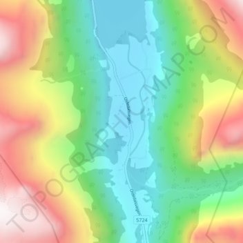
Name: Høgalmane topographic map, elevation, terrain.
Location: Høgalmane, Stryn, Vestland, 6791, Norway (61.67349 6.78653 61.71349 6.82653)
Average elevation: 540 m
Minimum elevation: 25 m
Maximum elevation: 1,430 m
Thank you for supporting this site ❤️
Make a donation
Make a donation
Other topographic maps
Click on a map to view its topography, its elevation and its terrain.
Thank you for supporting this site ❤️
Make a donation
Make a donation
Thank you for supporting this site ❤️
Make a donation
Make a donation