
Make a donation
Naxos topographic map
Click on the map to display elevation.
Make a donation
About this map
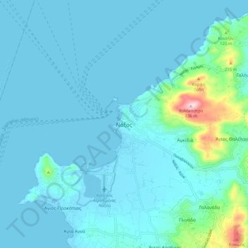
Name: Naxos topographic map, elevation, terrain.
Average elevation: 33 m
Minimum elevation: -2 m
Maximum elevation: 326 m
Make a donation
Other topographic maps
Click on a map to view its topography, its elevation and its terrain.
Naxos
Greece > Aegean > Naxos Regional Unit
Naxos experiences both a Mediterranean climate (Csa) and a hot semi-arid climate (Köppen climate classification: BSh) depending on the location. According to the stations of the National Observatory of Athens, various locations in Naxos have a hot semi-arid climate. Inland areas of the island are much wetter…
Average elevation: 112 m
Make a donation
Naxos
Greece > Aegean > Naxos Regional Unit
Naxos experiences both a Mediterranean climate (Csa) and a hot semi-arid climate (Köppen climate classification: BSh) depending on the location. According to the stations of the National Observatory of Athens, various locations in Naxos have a hot semi-arid climate. Inland areas of the island are much wetter…
Average elevation: 112 m