
Thank you for supporting this site ❤️
Make a donation
Make a donation
Majadita topographic map
Click on the map to display elevation.
Thank you for supporting this site ❤️
Make a donation
Make a donation
About this map
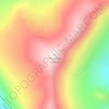
Name: Majadita topographic map, elevation, terrain.
Location: Majadita, Iglesia, San Juan, Argentina (-30.42012 -69.78098 -30.42002 -69.78088)
Average elevation: 5,968 m
Minimum elevation: 5,513 m
Maximum elevation: 6,260 m
Thank you for supporting this site ❤️
Make a donation
Make a donation
Other topographic maps
Click on a map to view its topography, its elevation and its terrain.