
Thank you for supporting this site ❤️
Make a donation
Make a donation
Konin topographic map
Click on the map to display elevation.
Thank you for supporting this site ❤️
Make a donation
Make a donation
About this map
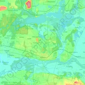
Name: Konin topographic map, elevation, terrain.
Location: Konin, Greater Poland Voivodeship, Poland (52.18226 18.19261 52.32998 18.33269)
Average elevation: 93 m
Minimum elevation: 74 m
Maximum elevation: 167 m
Thank you for supporting this site ❤️
Make a donation
Make a donation
Other topographic maps
Click on a map to view its topography, its elevation and its terrain.
Modlin
Poland > Greater Poland Voivodeship > Ostrów Wielkopolski County > Zamość
Average elevation: 131 m
Thank you for supporting this site ❤️
Make a donation
Make a donation
Thank you for supporting this site ❤️
Make a donation
Make a donation