
Thank you for supporting this site ❤️
Make a donation
Make a donation
Rouvières topographic map
Click on the map to display elevation.
Thank you for supporting this site ❤️
Make a donation
Make a donation
About this map
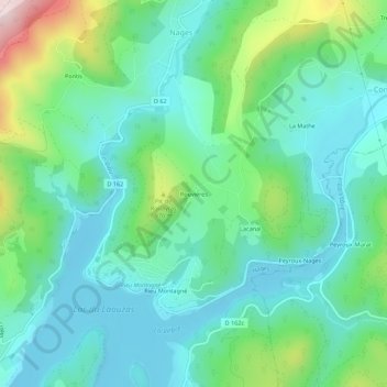
Name: Rouvières topographic map, elevation, terrain.
Average elevation: 862 m
Minimum elevation: 766 m
Maximum elevation: 1,159 m
Thank you for supporting this site ❤️
Make a donation
Make a donation
Other topographic maps
Click on a map to view its topography, its elevation and its terrain.
Lac du Laouzas
France > Occitanie > Tarn > Nages
Le lac est situé à une altitude de 790 m, dans les monts de Lacaune dans la région Occitanie. Il est alimenté par la rivière Vèbre qui est un affluent de l'Agout, ainsi que ses affluents rive droite, dont le Viau, et les ruisseaux de Rieufrech, Ramières et Pradas.
Average elevation: 849 m