
Make a donation
Santa Clara topographic map
Click on the map to display elevation.
Make a donation
About this map
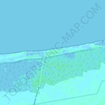
Name: Santa Clara topographic map, elevation, terrain.
Location: Santa Clara, Dzidzantún, Yucatán, Mexico (21.35361 -89.03070 21.39361 -88.99070)
Average elevation: 1 m
Minimum elevation: -4 m
Maximum elevation: 5 m
Make a donation
Other topographic maps
Click on a map to view its topography, its elevation and its terrain.
Mérida
Mérida is located in the northwest part of the state of Yucatán, which occupies the northern portion of the Yucatán Peninsula. To the east is the state of Quintana Roo, to the west is the state of Campeche, to the north is the Gulf of Mexico, and far to the south is the state of Chiapas. The city is also…
Average elevation: 8 m
Make a donation
Make a donation
Make a donation
Mérida
Mérida is located in the northwest part of the state of Yucatán, which occupies the northern portion of the Yucatán Peninsula. To the east is the state of Quintana Roo, to the west is the state of Campeche, to the north is the Gulf of Mexico, and far to the south is the state of Chiapas. The city is also…
Average elevation: 8 m
Make a donation
Make a donation
Mérida
Mérida is located in the northwest part of the state of Yucatán, which occupies the northern portion of the Yucatán Peninsula. To the east is the state of Quintana Roo, to the west is the state of Campeche, to the north is the Gulf of Mexico, and far to the south is the state of Chiapas. The city is also…
Average elevation: 8 m
Make a donation