
Make a donation
Aleu topographic map
Click on the map to display elevation.
Make a donation
Aleu
Aleu is located some 10 km south-east of Saint-Girons and 30 km west by south-west of Foix. It can be accessed by the D618 road coming from the west and following the northern border of the commune continuing to Biert in the east. The only access to the village by vehicle is by a small mountain road branching from the D618 at Castet d'Aleu. There is a small unsealed airstrip north-east of the village at approx 1000m altitude. The commune is very rugged with extensive forests. Apart from the village, there are numerous hamlets: Castet d'Aleu, Galas d'en Bas and Galas d'en Haut, La Trappe, La Bordasse, Biech, Pinsou, La Rouere and Fontale.
Make a donation
About this map
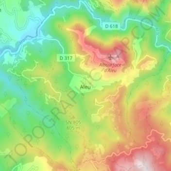
Name: Aleu topographic map, elevation, terrain.
Average elevation: 746 m
Minimum elevation: 491 m
Maximum elevation: 1,112 m
Make a donation
Other topographic maps
Click on a map to view its topography, its elevation and its terrain.
Make a donation
Make a donation
Mont Valier
France > Occitania > Ariège > Seix
On August 18, 2023, French general Jean-Louis Georgelin fell to his death while hiking on Mont Valier, at an altitude of 2,650 metres (8,690 ft).
Average elevation: 2,217 m
Make a donation
Make a donation
Make a donation