
Thank you for supporting this site ❤️
Make a donation
Make a donation
Sheikh Zayed topographic map
Click on the map to display elevation.
Thank you for supporting this site ❤️
Make a donation
Make a donation
About this map
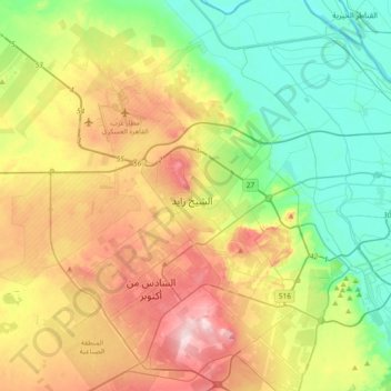
Name: Sheikh Zayed topographic map, elevation, terrain.
Location: Sheikh Zayed, Giza, 12588, Egypt (29.88835 30.82322 30.20835 31.14322)
Average elevation: 103 m
Minimum elevation: 4 m
Maximum elevation: 265 m
Thank you for supporting this site ❤️
Make a donation
Make a donation
Other topographic maps
Click on a map to view its topography, its elevation and its terrain.
Thank you for supporting this site ❤️
Make a donation
Make a donation
Thank you for supporting this site ❤️
Make a donation
Make a donation
Thank you for supporting this site ❤️
Make a donation
Make a donation
Thank you for supporting this site ❤️
Make a donation
Make a donation