
Make a donation
Daejeon topographic map
Click on the map to display elevation.
Make a donation
Daejeon
In 1973, Buk-myeon and Yuseong-myeon of Daedeok-gun were each elevated to Sintanjin-eup and Yuseong-eup, respectively. In 1977, the ward system (gu-je) was implemented in Daejeon, establishing two wards: Jung-gu and Dong-gu. In 1983, Daejeon further expanded by incorporating the entire areas of Yuseong-eup and Hoedeok-myeon of Daedeok-gun, and parts of Tan-dong, Gujeok, Jinjam, and Giseong-myeon. At this time, Daedeok-gun was split into two separate parts. This situation continued until 1989, when Daedeok-gun was abolished and Daejeon was elevated to a Directly Governed City. Just before this elevation in 1988, Seo-gu was separated from Jung-gu. In 1989, Daedeok-gun was abolished and merged into Daejeon, and the integrated Daejeon of Chungcheongnam-do was elevated to Daejeon Directly Governed City. Simultaneously, Yuseong District was separated from Seo-gu, and Daedeok District from Dong-gu, completing the current system of five districts.
Make a donation
About this map
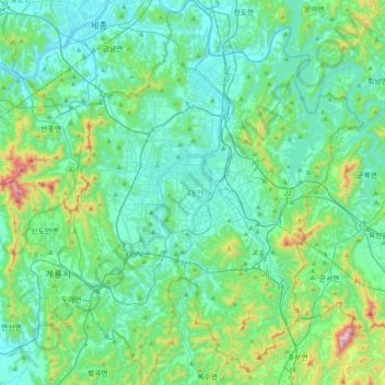
Name: Daejeon topographic map, elevation, terrain.
Location: Daejeon, South Korea (36.18337 127.24632 36.49988 127.55736)
Average elevation: 160 m
Minimum elevation: 7 m
Maximum elevation: 880 m
Make a donation
Other topographic maps
Click on a map to view its topography, its elevation and its terrain.