
Thank you for supporting this site ❤️
Make a donation
Make a donation
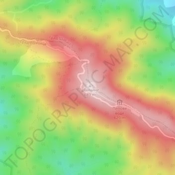
Cer topographic map
Click on the map to display elevation.
Thank you for supporting this site ❤️
Make a donation
Make a donation
Cer
Cer (pronounced [tsɛr]) is a mountain in western Serbia, 30 kilometers from Šabac, 100 kilometers west of Belgrade. The highest peak has an elevation of 689 m (2,260 ft) above sea level. Cer is rich in the Turkey oak forests after which it was named.
Thank you for supporting this site ❤️
Make a donation
Make a donation
About this map
Name: Cer topographic map, elevation, terrain.
Average elevation: 480 m
Minimum elevation: 257 m
Maximum elevation: 681 m
Thank you for supporting this site ❤️
Make a donation
Make a donation