
Thank you for supporting this site ❤️
Make a donation
Make a donation
Mount Agung topographic map
Click on the map to display elevation.
Thank you for supporting this site ❤️
Make a donation
Make a donation
Mount Agung
Australia's Bureau of Meteorology reported on 27 November that ash from the eruption had been observed at an altitude of 9,144 m. By the beginning of December, the eruption reduced to minor emissions of steam and smoke. On 12 December, a picture of the crater was taken showing a steadily growing lava dome occupying approximately one third of the crater.
Thank you for supporting this site ❤️
Make a donation
Make a donation
About this map
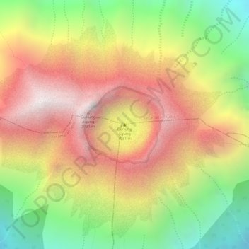
Name: Mount Agung topographic map, elevation, terrain.
Average elevation: 2,534 m
Minimum elevation: 1,950 m
Maximum elevation: 3,010 m
Thank you for supporting this site ❤️
Make a donation
Make a donation
Other topographic maps
Click on a map to view its topography, its elevation and its terrain.
Thank you for supporting this site ❤️
Make a donation
Make a donation
Thank you for supporting this site ❤️
Make a donation
Make a donation
Thank you for supporting this site ❤️
Make a donation
Make a donation