
Thank you for supporting this site ❤️
Make a donation
Make a donation
Bludenz topographic map
Click on the map to display elevation.
Thank you for supporting this site ❤️
Make a donation
Make a donation
About this map
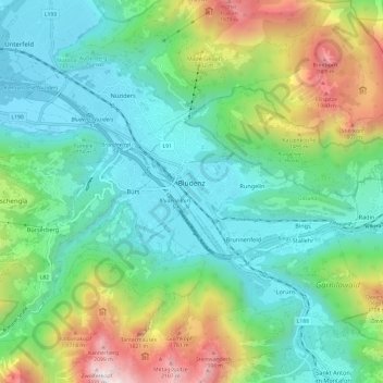
Name: Bludenz topographic map, elevation, terrain.
Location: Bludenz, Bezirk Bludenz, Vorarlberg, 6700, Austria (47.12491 9.80230 47.17752 9.92269)
Average elevation: 1,003 m
Minimum elevation: 522 m
Maximum elevation: 2,251 m
Thank you for supporting this site ❤️
Make a donation
Make a donation
Other topographic maps
Click on a map to view its topography, its elevation and its terrain.
Montafon
Austria > Vorarlberg > Bezirk Bludenz > Gemeinde Sankt Gallenkirch
Tourism plays a vital role and the Montafon is well-known for its skiing, hiking, and mountain biking. The Silvretta high alpine road (German: Hochalpenstraße) gives access to remote ski areas that are located altitudes of 650 to 1,430 meters. The construction of the Montafon Railway in 1905 also helped…
Average elevation: 1,566 m