
Thank you for supporting this site ❤️
Make a donation
Make a donation
Seehöhe topographic map
Click on the map to display elevation.
Thank you for supporting this site ❤️
Make a donation
Make a donation
Seehöhe
Cierzpięty (deutsch Czierspienten, 1905–1945 Seehöhe) ist ein Dorf in der polnischen Woiwodschaft Ermland-Masuren, das zur Gmina Orzysz (Stadt- und Landgemeinde Arys) im Powiat Piski (Kreis Johannisburg) gehört.
Thank you for supporting this site ❤️
Make a donation
Make a donation
About this map
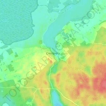
Name: Seehöhe topographic map, elevation, terrain.
Average elevation: 133 m
Minimum elevation: 110 m
Maximum elevation: 173 m
Thank you for supporting this site ❤️
Make a donation
Make a donation