
Thank you for supporting this site ❤️
Make a donation
Make a donation
Avões topographic map
Click on the map to display elevation.
Thank you for supporting this site ❤️
Make a donation
Make a donation
About this map
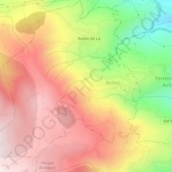
Name: Avões topographic map, elevation, terrain.
Location: Avões, Lamego, Viseu, Portugal (41.10283 -7.86019 41.13028 -7.82359)
Average elevation: 701 m
Minimum elevation: 325 m
Maximum elevation: 1,001 m
Thank you for supporting this site ❤️
Make a donation
Make a donation
Other topographic maps
Click on a map to view its topography, its elevation and its terrain.
Thank you for supporting this site ❤️
Make a donation
Make a donation
Thank you for supporting this site ❤️
Make a donation
Make a donation