
Thank you for supporting this site ❤️
Make a donation
Make a donation
St. Pölten topographic map
Click on the map to display elevation.
Thank you for supporting this site ❤️
Make a donation
Make a donation
St. Pölten
Die komplette Liste der Statistik Austria ist in: Topographische Siedlungskennzeichnung nach STAT
Thank you for supporting this site ❤️
Make a donation
Make a donation
About this map
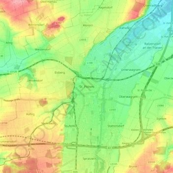
Name: St. Pölten topographic map, elevation, terrain.
Location: St. Pölten, Niederösterreich, 3102, Österreich (48.16440 15.58291 48.24440 15.66291)
Average elevation: 286 m
Minimum elevation: 241 m
Maximum elevation: 345 m
Thank you for supporting this site ❤️
Make a donation
Make a donation