
Make a donation
Santa Maria del Piano topographic map
Click on the map to display elevation.
Make a donation
About this map
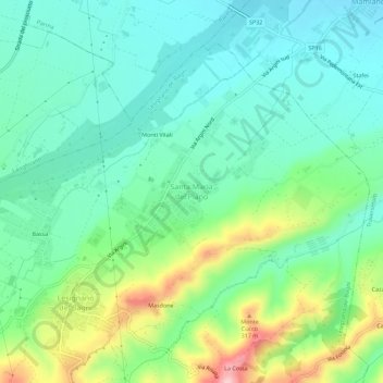
Name: Santa Maria del Piano topographic map, elevation, terrain.
Average elevation: 214 m
Minimum elevation: 155 m
Maximum elevation: 363 m
Make a donation
Other topographic maps
Click on a map to view its topography, its elevation and its terrain.
Make a donation
Make a donation
Make a donation
Make a donation
Parma
Italy > Emilia-Romagna > Parma
During World War II, Parma was a strong centre of partisan resistance. The train station and marshalling yards were targets for high altitude bombing by the Allies in the spring of 1944. Much of the Palazzo della Pilotta, situated not far (half a mile) from the train station, was destroyed. Along with it the…
Average elevation: 85 m
Make a donation
Make a donation