
Thank you for supporting this site ❤️
Make a donation
Make a donation
Glödnitz topographic map
Click on the map to display elevation.
Thank you for supporting this site ❤️
Make a donation
Make a donation
About this map
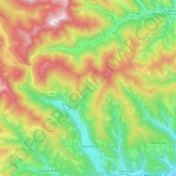
Name: Glödnitz topographic map, elevation, terrain.
Average elevation: 1,179 m
Minimum elevation: 684 m
Maximum elevation: 1,931 m
Thank you for supporting this site ❤️
Make a donation
Make a donation
Other topographic maps
Click on a map to view its topography, its elevation and its terrain.
Thank you for supporting this site ❤️
Make a donation
Make a donation
Kötschendorf
Österreich > Kärnten > Bezirk St. Veit an der Glan > Weitensfeld im Gurktal
Average elevation: 947 m
Thank you for supporting this site ❤️
Make a donation
Make a donation
Weindorf
Österreich > Kärnten > Bezirk St. Veit an der Glan > Sankt Georgen am Längsee
Average elevation: 612 m
Thank you for supporting this site ❤️
Make a donation
Make a donation
Rauscheggen
Österreich > Kärnten > Bezirk St. Veit an der Glan > Deutsch-Griffen
Average elevation: 1,188 m
Einöd
Österreich > Kärnten > Bezirk St. Veit an der Glan > Frauenstein > Kraig
Average elevation: 735 m
Thank you for supporting this site ❤️
Make a donation
Make a donation
Thank you for supporting this site ❤️
Make a donation
Make a donation
Thank you for supporting this site ❤️
Make a donation
Make a donation
Pörlinghof
Österreich > Kärnten > Bezirk St. Veit an der Glan > Frauenstein > Überfeld
Average elevation: 597 m