
Thank you for supporting this site ❤️
Make a donation
Make a donation
Zöbing topographic map
Click on the map to display elevation.
Thank you for supporting this site ❤️
Make a donation
Make a donation
Zöbing
Der Ort liegt im Kamptal zwischen Schönberg am Kamp und Langenlois. Die Seehöhe in der Ortsmitte beträgt 211 Meter. Die Fläche der Katastralgemeinde umfasst 5,39 km². Die Einwohnerzahl beläuft sich auf 803 Einwohner (Stand: 1. Jänner 2023).
Thank you for supporting this site ❤️
Make a donation
Make a donation
About this map
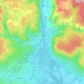
Name: Zöbing topographic map, elevation, terrain.
Average elevation: 270 m
Minimum elevation: 203 m
Maximum elevation: 401 m
Thank you for supporting this site ❤️
Make a donation
Make a donation