
Make a donation
Aabri topographic map
Click on the map to display elevation.
Make a donation
About this map
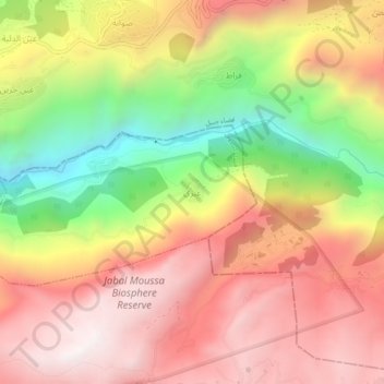
Name: Aabri topographic map, elevation, terrain.
Average elevation: 1,052 m
Minimum elevation: 367 m
Maximum elevation: 1,569 m
Make a donation
Other topographic maps
Click on a map to view its topography, its elevation and its terrain.
Make a donation
Make a donation
Make a donation
Mounsef
Lebanon > Keserwan-Jbeil Governorate
Mounsef (Arabic: المنصف, also spelled al-Mounsif) is a municipality in the Byblos District of Keserwan-Jbeil Governorate, Lebanon. It located off the Mediterranean coast and is 47 kilometers north of Beirut. Mounsef has an average elevation of 220 meters above sea level and a total land area of 341…
Average elevation: 127 m
Make a donation
Make a donation
Make a donation
Make a donation
Make a donation
Make a donation
Make a donation
Make a donation
Make a donation
Zouk Mosbeh
Lebanon > Keserwan-Jbeil Governorate
Zouk Mosbeh (Arabic: زوق مصبح) is a town and municipality in the Keserwan District of the Keserwan-Jbeil Governorate in Lebanon. It is located 12 kilometers north of Beirut. Zouk Mosbeh's average elevation is 170 meters above sea level and its total land area is 453 hectares. Its inhabitants are…
Average elevation: 114 m
Make a donation
Ghazir
Lebanon > Keserwan-Jbeil Governorate
Ghazir (Arabic: غزير) is a town and municipality in the Keserwan District of the Keserwan-Jbeil Governorate of Lebanon. It is located 27 kilometres (17 mi) north of Beirut. It has an average elevation of 380 meters above sea level and a total land area of 542 hectares (2.09 sq mi). The town has four…
Average elevation: 359 m
Make a donation
Make a donation