
Thank you for supporting this site ❤️
Make a donation
Make a donation
Hozémont topographic map
Click on the map to display elevation.
Thank you for supporting this site ❤️
Make a donation
Make a donation
About this map
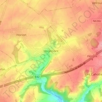
Name: Hozémont topographic map, elevation, terrain.
Location: Hozémont, Grâce-Hollogne, Liège, Wallonie, 4460, Belgique (50.60487 5.37654 50.64487 5.41654)
Average elevation: 164 m
Minimum elevation: 96 m
Maximum elevation: 203 m
Thank you for supporting this site ❤️
Make a donation
Make a donation
Other topographic maps
Click on a map to view its topography, its elevation and its terrain.