
Thank you for supporting this site ❤️
Make a donation
Make a donation
Koszalin topographic map
Click on the map to display elevation.
Thank you for supporting this site ❤️
Make a donation
Make a donation
About this map
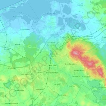
Name: Koszalin topographic map, elevation, terrain.
Location: Koszalin, West Pomeranian Voivodeship, Poland (54.13737 16.08053 54.27699 16.32331)
Average elevation: 27 m
Minimum elevation: -6 m
Maximum elevation: 134 m
Thank you for supporting this site ❤️
Make a donation
Make a donation
Other topographic maps
Click on a map to view its topography, its elevation and its terrain.
Wzgórze Grodowe
Poland > West Pomeranian Voivodeship > Pyrzyce County > Lipiany
Average elevation: 67 m
Thank you for supporting this site ❤️
Make a donation
Make a donation
Thank you for supporting this site ❤️
Make a donation
Make a donation