
Thank you for supporting this site ❤️
Make a donation
Make a donation
Münsterhalden topographic map
Click on the map to display elevation.
Thank you for supporting this site ❤️
Make a donation
Make a donation
About this map
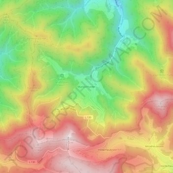
Name: Münsterhalden topographic map, elevation, terrain.
Average elevation: 810 m
Minimum elevation: 447 m
Maximum elevation: 1,137 m
Thank you for supporting this site ❤️
Make a donation
Make a donation
Other topographic maps
Click on a map to view its topography, its elevation and its terrain.
Obermünstertal
Deutschland > Baden-Württemberg > Landkreis Breisgau-Hochschwarzwald > Münstertal
Average elevation: 687 m