
Make a donation
Morgat topographic map
Click on the map to display elevation.
Make a donation
About this map
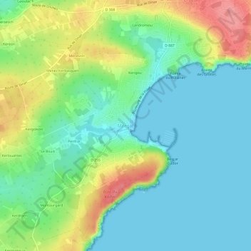
Name: Morgat topographic map, elevation, terrain.
Average elevation: 30 m
Minimum elevation: 0 m
Maximum elevation: 95 m
Make a donation
Other topographic maps
Click on a map to view its topography, its elevation and its terrain.
Make a donation
Make a donation
Make a donation
La Feuillée
The village is situated in the Monts d'Arrée, a moorland area in the northern part of the Finistère. The village centre is located 21 km (13 mi) south of Morlaix and 47 km (29 mi) east of Brest. The village centre is the highest in Brittany. It is at an altitude of 275 meters. It is surrounded by several…
Average elevation: 258 m
Make a donation
Make a donation
Make a donation
Make a donation
Make a donation
Make a donation
Spézet
Spézet is a rural municipality in east central Finistère, historically belonging to Cornouaille. It is bounded on the west and north by the river the Aulne and Hyères describing large meanders (Nantes-Brest Canal-channel) while at the southeast end of its territory lies Roc'h Toullaëron, which from its…
Average elevation: 136 m
Make a donation
Make a donation
Make a donation
Manoir de Cœcilian (Saint-Pol-Roux)
France > Brittany > Finistère > Camaret-sur-Mer
Average elevation: 17 m
Make a donation
Make a donation
Carhaix-Plouguer
France > Brittany > Finistère > Carhaix-Plouguer
Carhaix is located in the Poher, an important territory of Brittany, sandwiched between the Arrée Mountains to the north and the Black Mountains to the south. The agglomeration developed mainly on a plateau located at 140 meters above sea level, gently sloping towards the west, the highest elevations being…
Average elevation: 120 m
Make a donation
Make a donation
Make a donation