
Make a donation
Munich topographic map
Click on the map to display elevation.
Make a donation
Munich
Munich lies on the elevated plains of Upper Bavaria, about 50 km (31 mi) north of the northern edge of the Alps, at an altitude of about 520 m (1,706 ft) ASL. The local rivers are the Isar and the Würm. Munich is situated in the Northern Alpine Foreland. The northern part of this sandy plateau includes a highly fertile flint area which is no longer affected by the folding processes found in the Alps, while the southern part is covered with morainic hills. Between these are fields of fluvio-glacial out-wash, such as around Munich. Wherever these deposits get thinner, the ground water can permeate the gravel surface and flood the area, leading to marshes as in the north of Munich.
Make a donation
About this map
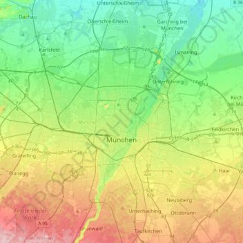
Name: Munich topographic map, elevation, terrain.
Location: Munich, Bavaria, Germany (48.06162 11.36078 48.24812 11.72291)
Average elevation: 524 m
Minimum elevation: 466 m
Maximum elevation: 633 m
Make a donation
Other topographic maps
Click on a map to view its topography, its elevation and its terrain.
Allgäu
The alpine regions of the Allgäu rise over 2,000 metres in elevation and are popular for winter skiing. The Allgovian area is notable for its beautiful landscapes and is popular for vacations and therapeutic stays. It is well known in Germany for its farm produce, especially dairy products including…
Average elevation: 1,087 m