
Make a donation
Sa Pa topographic map
Click on the map to display elevation.
Make a donation
Sa Pa
The Hoàng Liên Sơn mountain range, which includes Vietnam's highest mountain, Fansipan, dominates the area. Situated at an average elevation of about 1,600 m (5,200 ft), Sa Pa is characterized by a montane ecosystem. Remnants of old-growth forest featuring unique trees like the critically endangered Fansipan fir can be found from around 2,000–2,500 m (6,562–8,202 ft) above sea level. A dwarf forest is found at 2,500–3,000 m (8,202–9,843 ft), while at higher elevations, only the hardiest of plant species are found, such as certain species of dwarf bamboo. The Hoàng Liên Mountains are home to a wide variety of plants and animals, many of which are endemic to Northwest Vietnam. For this reason, Hoàng Liên National Park was established in 2006, covering much of the mountain range to the immediate south of Sa Pa. The Muong Hoa Valley, which has been terraced for wet rice agriculture, is situated between Fansipan and Sa Pa town.
Make a donation
About this map
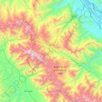
Name: Sa Pa topographic map, elevation, terrain.
Location: Sa Pa, Xã Tả Van, Lào Cai Province, Vietnam (22.13742 103.72865 22.49334 104.08359)
Average elevation: 1,270 m
Minimum elevation: 70 m
Maximum elevation: 3,094 m
Make a donation