
Thank you for supporting this site ❤️
Make a donation
Make a donation
Crêt de Charmont topographic map
Click on the map to display elevation.
Thank you for supporting this site ❤️
Make a donation
Make a donation
About this map
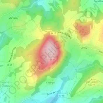
Name: Crêt de Charmont topographic map, elevation, terrain.
Average elevation: 586 m
Minimum elevation: 477 m
Maximum elevation: 748 m
Thank you for supporting this site ❤️
Make a donation
Make a donation
Other topographic maps
Click on a map to view its topography, its elevation and its terrain.
Mortéry
France > Auvergne-Rhône-Alpes > Haute-Savoie > Menthonnex-sous-Clermont
Average elevation: 582 m