
Thank you for supporting this site ❤️
Make a donation
Make a donation
La Cuesta topographic map
Click on the map to display elevation.
Thank you for supporting this site ❤️
Make a donation
Make a donation
La Cuesta
La Cuesta has an area of 37.06 km² and an elevation of 38 metres.
Thank you for supporting this site ❤️
Make a donation
Make a donation
About this map
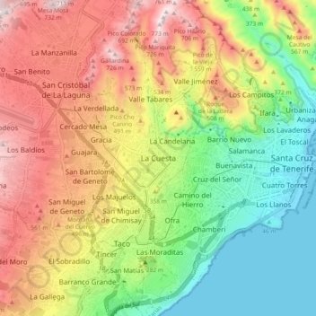
Name: La Cuesta topographic map, elevation, terrain.
Average elevation: 339 m
Minimum elevation: -1 m
Maximum elevation: 751 m
Thank you for supporting this site ❤️
Make a donation
Make a donation