
Thank you for supporting this site ❤️
Make a donation
Make a donation
Highland Mills topographic map
Click on the map to display elevation.
Thank you for supporting this site ❤️
Make a donation
Make a donation
About this map
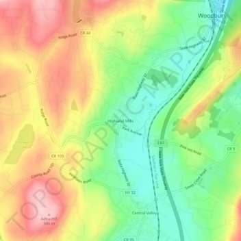
Name: Highland Mills topographic map, elevation, terrain.
Average elevation: 208 m
Minimum elevation: 121 m
Maximum elevation: 305 m
Thank you for supporting this site ❤️
Make a donation
Make a donation
Other topographic maps
Click on a map to view its topography, its elevation and its terrain.
Schunnemunk State Park
United States > New York > Orange County > Village of Woodbury
Average elevation: 213 m