
Seoul topographic map
Interactive map
Click on the map to display elevation.
About this map
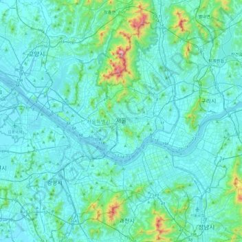
Name: Seoul topographic map, elevation, terrain.
Location: Seoul, South Korea (37.42854 126.76443 37.70148 127.18377)
Average elevation: 80 m
Minimum elevation: 1 m
Maximum elevation: 810 m
Other topographic maps
Click on a map to view its topography, its elevation and its terrain.
Gangwon
South Korea > Gangwon-do > Chuncheon-si > Bongui-dong
Gangwon, 모수물길, Bongui-dong, Chuncheon-si, Gangwon-do, 24267, South Korea
Average elevation: 95 m
Gyeonggi
South Korea > Gyeonggi-do > Suwon-si > Gyo-dong
Gyeonggi, Paldalsan-ro, Gyo-dong, Paldal-gu, Suwon-si, Gyeonggi-do, 16251, South Korea
Average elevation: 53 m
Dongbu-ri
South Korea > Ulsan > Ulju-gun > Dongbu-ri
Dongbu-ri, Ulju-gun, Ulsan, 44953, South Korea
Average elevation: 119 m
Incheon
South Korea > Incheon > Jung-gu
Unseo-dong, Jung-gu, Incheon, South Korea
Average elevation: 9 m
Jangjeon-dong
South Korea > Busan > Jangjeon-dong
Jangjeon-dong, Geumjeong-gu, Busan, South Korea
Average elevation: 122 m