
Make a donation
Rioja topographic map
Click on the map to display elevation.
Make a donation
Rioja
The mountains in La Rioja are part of the Iberian System. This mountain range extends to the south of the Ebro river, parallel to it at a distance of about 40 to 60 km (25 to 37 miles), with altitudes ranging between 1,000 and 2,000 m (3,300 and 6,600 feet). From the mountain range the Sierra de la Demanda runs northwards, into the heart of La Rioja, incorporating Monte San Lorenzo which, at 2,271 m (7,451 ft), is the highest peak in the province. Other mountains include Sierra de Camero Viejo, Sierra de Camero Nuevo, Sierra de Cebollera, and Picos de Urbión.
Make a donation
About this map
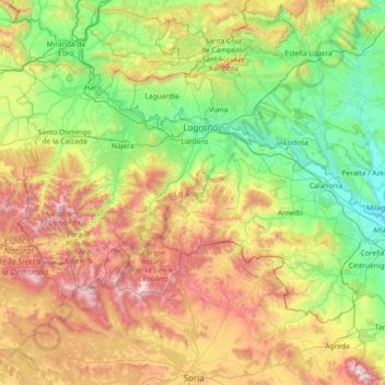
Name: Rioja topographic map, elevation, terrain.
Location: Rioja, Spain (41.91903 -3.13427 42.64426 -1.67870)
Average elevation: 873 m
Minimum elevation: 269 m
Maximum elevation: 2,298 m
Make a donation
Other topographic maps
Click on a map to view its topography, its elevation and its terrain.
Make a donation
Make a donation
Make a donation
Corró d'Amunt
Spain > Catalonia > Vallès Oriental > les Franqueses del Vallès
Average elevation: 287 m
Make a donation
Alhambra
Spain > Andalusia > Partido Judicial de Granada > Granada
During the reign of the Nasrid Dynasty, the Alhambra was transformed into a palatine city, complete with an irrigation system composed of aqueducts and water channels that provided water for the complex and for other nearby countryside palaces such as the Generalife. Previously, the old fortresses on the hill…
Average elevation: 759 m
Make a donation
Make a donation
Make a donation
Make a donation
Make a donation
"El Cerro la Silla" (Cima oeste)
Spain > Aragon > Campo de Cariñena > Cosuenda
Average elevation: 954 m
Make a donation
Make a donation
Make a donation
Make a donation
Make a donation
Peñon de Bodíjar
Spain > Andalusia > Comarca de la Costa Granadina > Los Guájares
Average elevation: 870 m
Make a donation
Make a donation
Make a donation
Cortijo ruinas
Spain > Andalusia > Comarca de la Alpujarra Granadina > Capileira
Average elevation: 2,246 m
Poblado de Doña Blanca
Spain > Andalusia > Bay of Cádiz > El Puerto de Santa María
Average elevation: 13 m
Make a donation
Parque de la Puerta de Tierra
Spain > Canary Islands > San Juan del Reparo (La Culata) > San Pedro de Daute
Average elevation: 182 m
Make a donation
Make a donation
Marabi
Spain > Autonomous Community of the Basque Country > Amorebieta-Etxano
Average elevation: 161 m
La Mata
Spain > Valencian Community > el Baix Segura / La Vega Baja > Torrevieja
Average elevation: 5 m
Make a donation
Make a donation
Make a donation
Make a donation
Make a donation